Florida Land, Water, Resource Study Guide
VOCABULARY
· Geography: The study that teaches us about people and places
· Relative location: Where a place is, compared with one or more other places on Earth.
· Straight: a narrow body of water that connects two larger bodies of water.
· Continental Shelf: The part of Florida’s peninsula that remained underwater
· Estuary: A place where freshwater from a river nixes with salt water from the ocean.
· Panhandle: The part of Florida that stretches west to Alabama. It is called the Panhandle because it sticks
out like the handle of a pan.
· Peninsula: A landform consisting of land surrounded on three sides by water
· Climate: The kind of weather a place has over a long period of time.
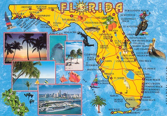
STUDY (You will be provided with a map of
Florida)
· The relative location of Florida to most of the other states in the United States is the Southeast.
· The two states that border Florida are Alabama and Georgia
· The straights of Florida connect the Gulf of Mexico and the Atlantic Ocean.
· Florida’s largest natural region is the Coastal Lowlands. It is very flat and has many of the state’s
largest cities and savannas.
· The Western Highlands is a natural region in the panhandle and is home of the highest point in Florida
which is near Lakewood in Walton County
· The Wetlands is a natural region which includes the Everglades
· Florida’s largest lake is Lake Okeechobee
· Florida’s longest river is the St. Johns river
· Phosphate is mainly used to manufacture fertilizer
· Florida’s underground resources include sand, gravel, and clay
· Most of Florida’s little used land is in the wetlands
· The capital of Florida is Tallahassee
· Winter in southern Florida is warmer than winter in northern Florida
· Given a description of two regions of Florida, be able to tell how the two regions are alike and different
in two to five sentences
· Be able to use latitude and longitude (latitude comes first and is N or S, longitude is E or W and comes
second.)
· Be able to read a resource and land use map